The following link will take you to the web site called ‘Where’s The Path’, where you can view an OS map for our area, in conjunction with views of the actual terrain, to help you find and plan your walking route. We hope to bring you individual maps for our local walks very soon.
Meantime, the web page you will visit has several different controls to help you explore our area – have fun!
WALK OF THE MONTH
As part of Meidrim Community Council working in tandem with Public Rights of Way to improve the public footpath network in the parish, we’ll be featuring a “Walk of the Month” to promote and raise awareness of improved paths.
Paths need to be used by locals and tourists alike in order to keep them maintained and fully functional, where problems can be reported and addressed, as well as the wearing-in of paths underfoot. Many of the paths in the parish have become problematic for this reason, and we aim to open and improve as many of them as possible, as well as creating walking links between different villages in the vicinity.
Featured walks will generally avoid any walking on main roads, perhaps with the only exception of crossing over, and perhaps walking part-way on minor, quiet, single-track roads.
Featured Walk of the Month:
MEIDRIM YOUTH HALL – CWMPALIS WOODS – GIBEON – PENBIGWRN – YOUTH HALL
This is an approximately three mile circular walk that begins and ends at the Youth Hall. Many will be familiar with the old “by way” or “green road” that runs down past the youth hall and through Pantglas Farm, towards Pant y Brodyr. This was cleared of scrub during lockdown, and while it is no longer suitable or wide enough for vehicular access, it has physically grown and transformed into a wide footpath that is now waymarked. This is a beautiful stretch of woodland – be sure to check it out during spring when dazzling carpets of bluebells cover the woodland floor and the smell of wild garlic fills the air.
Carry on down this path until you reach Pant y Brodyr Farm. Upon entering the farmyard, turn left and follow the way markers through Cwmpalis woods. This path was recently cleared and fully waymarked. Follow the way markers down through the field, follow the road out of Cwmpalis and emerge onto the Gibeon Road. Take a left and head up towards Gibeon chapel. Notice on your left a hilltop summit containing the old ditch banks of an iron age hill fort. Take a left at the crossroads, signposted “Meidrim” and follow the road to Penbigwrn. This stretch affords some marvellous views of the Black Mountains, the opening to the estuary at Laugharne and the surrounding landscape south of the ridge.
When approaching Penbigwrn, be sure to look through the opposite gate at the view of the Preseli hills. At Penbigwrn, turn left and cross over the cattle grid and walk to the end of the lane. Enter the footpath on your right, signposted and waymarked. There is a spectacular spot midway in this first field, essentially the summit of the big hill you see in front of you at Meidrim, where the views of the surrounding landscape are almost panoramic, and one of those rare spots where both The Black Mountains and The Preseli Hills can be seen in either direction.
Follow the way markers and emerge into the next field, you will be surprised at the sight of the almost aerial view of the village below, which feels much higher than the hills appear from below. This particular footpath has recently undergone lots of improvements, including new stiles and installed gates. Follow this path down the hill, following the way markers, and emerge through the gate at the Youth Hall.
MARCH WALK OF THE MONTH – NORTH-WEST PARISH CIRCULAR
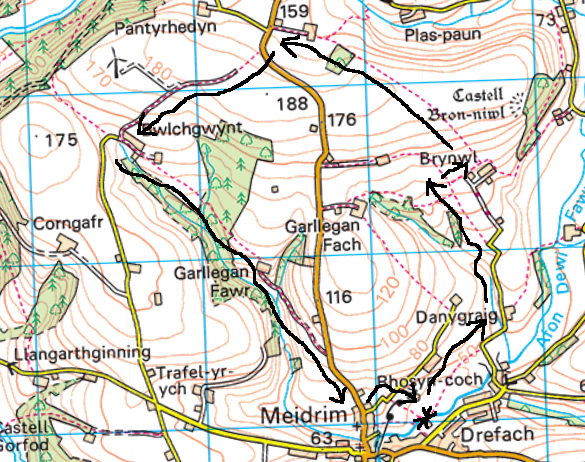
This approximately five-mile circular walk takes us through the north-west of the parish through some of the highest points in the area with magnificent views over wooded valleys, where the Black Mountains, The Preseli Hills and The Gower Peninsula can be seen. It comprises of many different landscape features, from hills and vantage points to natural woodland, plantation, and brooks. If you’re looking for long stretches of continual footpath with minimal walking on lanes, this is an ideal walk. It also provides safe access into Gellywen forestry from Meidrim village with its numerous tracks and paths.
This route starts at the village green. Take the village green path next to the river and veer left, following the way markers. Please be aware that this is the lowest point of the village, and this path may be boggy and/or flooded after heavy rain. An alternative route is via turning left at the crossroads at the end of the Drefach Road.
Emerge from the footpath onto the lane and follow the lane straight ahead. Near the end of this lane after veering left at the farm is a pedestrian gate and footpath sign. Follow this path through fields as you begin a gradual ascent. At the top of these fields the footpath veers right onto a short track near Brynwl Farm. Here the footpath splits two ways. Follow the track to the left and take a sharp turn. This wide ascending track is an old ‘hollow way’, which is formed by erosion, water and farm traffic and likely dates back to the iron-age. In the fields to the right here is Castell Bron-Niwl, an old iron-age fort that was unfortunately structurally removed a few decades ago, but the rings on the ground still exist. At one time, it was the most impressive of the three known iron-age forts in the parish. Please keep in mind this iron-age fort exists on private land, isn’t part of the footpath and isn’t currently accessible.
At the top of the hollow-way, enter through the pedestrian gate and follow the way markers through the fields. Here is one of the highest points in the parish and the views are vast. The solitude, quiet and vast views over the county are quite an experience on a clear, sunny day with good visibility.
Follow this long stretch of path and emerge into Waun-Oleu-Fach Farm. There is a gate here which isn’t properly fastened and is held together with a removable, clasped chain. Please ensure you affix the chain after passing through this gate.
At this point, cross over the B4299 (Trelech Road) and veer left. Pass through the pedestrian gate and enter onto the next section of footpath, which is an open, wide farm track, with the second section of this track also being an old ‘hollow-way’ as it descends down into Bwlchgwynt.
At Bwlchgwynt, the path splits. Here you can go right if you wish and onto the footpath that enters Gellywen forestry.
For this circular route, turn left and take the footpath through Bwlchgwynt Farm, which leads through a field and down into a brook, followed by a plantation. Follow the path through Garllegan Fawr, following the woodland track, which eventually emerges onto the B4299, just outside of the village.
There is about two hundred yards of walking alongside the B4299 here, until you reach the first lane veering off to the left, as you approach the “Welcome to Meidrim sign”. Turn left onto this lane and eventually you will approach the footpath on the right leading back to the village green.
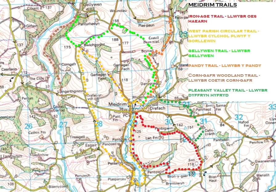
All circular walks recommended by Meidrim Community Council have been checked and fully waymarked.
As with all rights of way, please keep dogs on leads when passing through fields or farms, and please ensure you close all gates.
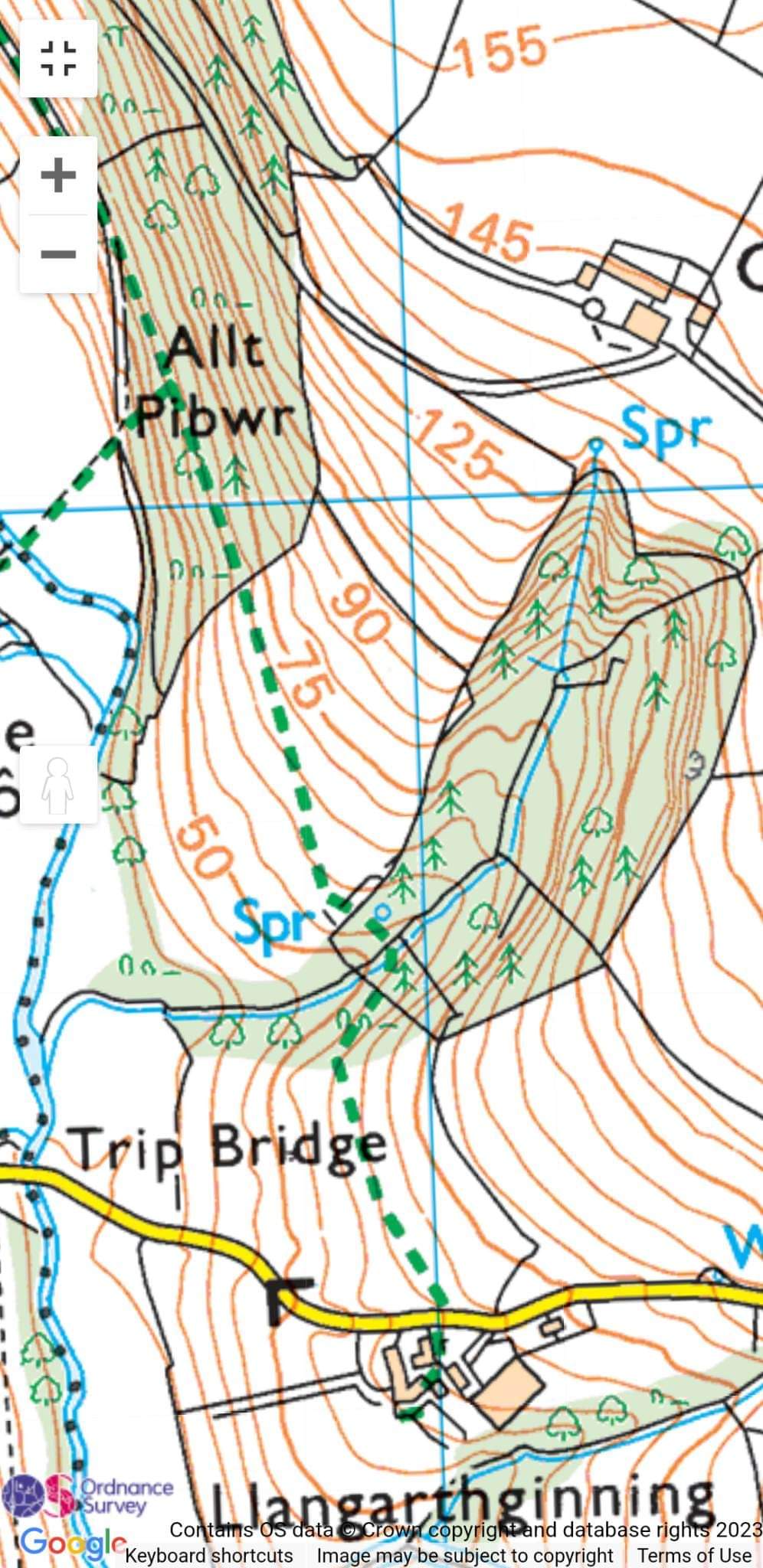
Footpath 53/21 – Llangarthginning Farm (Trip) to Gellywen, via the forestry has been cleared. The section of path that leads through Allt Pibwr (Pipers Wood) had suffered from years of non-use, resulting in thick brambles and overgrowth. Needless to say, the path through needs wearing-in underfoot, but it is now accessible all the way through to the old Corn Gafr disused Farm and beyond. There are also plans to widen the path through Allt Pibwr over the next few weeks.
This affords the residents at Trip and the wider community at Meidrim safer access into the forestry, due to access via the quieter Llanboidy Road.
Some sections of the path are muddy due to previously thick overgrowth and the inability of sunlight to penetrate these sections of the path, so make sure you wear good boots/wellies!
WALK OF THE MONTH – PLEASANT VALLEY TO THE LAN
This is a slightly shorter walk than previous ones and encompasses some of the footpaths used in a previous “Walk of the Month”.
There are two routes for this path. A shorter walk with superb views of the village, or a longer walk back through Cwmpalis woods and Pant Y Brodyr.
The only contact with a main road for this walk is crossing the B4298 (road from Meidrim to Carmarthen) and whilst not an overly busy road, cars can drive fast along this stretch, though there is a wide, mowed grass verge where crossing is required.
Begin the walk at the village green. Heading up-stream, take the path veering left that goes through Meidrim common. After passing through the strip of woodland and two fields, emerge onto the lane (this exit gate is fastened with a removable, clasped chain. Please remember to re-attach it).
Take a sharp right down the lane, passing over the old stone bridge that crosses the Avon Dewi Fawr and emerge at the crossroads at Drefach.
Walk straight ahead and onto the quiet lane that leads through Pleasant Valley. Before reaching the first house on the left (Pleasant View), enter onto the sign-posted footpath on your right and follow the way markers down through Pleasant Valley. Note the waterfall to your left as you descend down the woodland path and over the foot-bridge.
For those who have never walked this footpath, Pleasant Valley certainly lives up to it’s name – a tranquil, picturesque secluded meadow that is the epitome of some of the beautiful landscapes we live within. Just along the valley on the right, hidden in the woodland, is one of the three known iron-age hillforts within the parish (excluding the fourth that the church is built upon). The countryside is obviously teeming with colour and wildflowers this time of year – from Red Campion, to Cow Parsley, Herb Robert and the last remnants of Bluebells, to name a few.
Continue to follow the way markers up through Penrheol. Pass through the gate that runs alongside the farm and turn right onto the farm track, heading towards the B4298. Here you’ll pass a pond with a family of ducks.
When you’ve reached the B4298, veer slightly left and cross the road, entering onto the next sign-posted footpath that leads through fields and up the hill. Follow this path as it ascends left. Upon entering Cefn Crwth farm through the gate (the gate is old and little stiff, give it a good push), veer right and follow the track out of the farm. You might notice that the footpath on the ordnance survey map goes slightly to the left of the farm and through the fields, but this section of the path no longer exists and is currently being investigated by Public Rights of Way, so please use the main track out of the farm. Here is another gem in terms of panoramic, wide-open views of the surrounding landscape, and a feeling of expanse, especially on a sunny day.
Follow this track right to the end, emerging onto the quiet Gibeon Road (a little-used ridgeway and single-track road for those unfamiliar or new to the parish).
Here there are two options – a shorter walk with impressive views of the village, or a longer walk with lots of tranquil woodland.
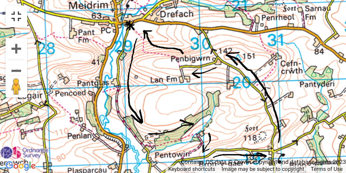
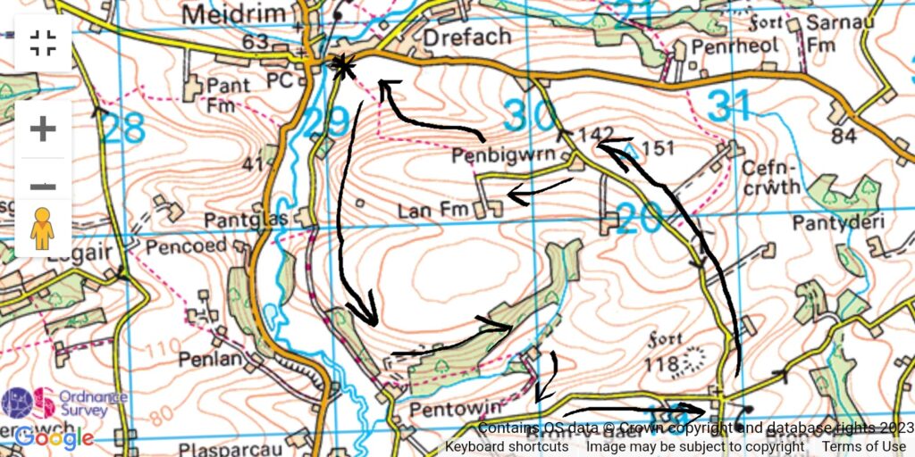
Shorter route (approximately two miles): Turn right and follow the path to Penbigwrn. Veer a sharp left here, over the cattle grid and follow the road to the end, where the footpath down to the youth hall is signposted on your right. As mentioned in a previous “Walk of the Month”, this is probably one of the best footpaths for views in the parish. Follow the waymarker discs down the hill and emerge at the youth hall.
Longer route – Marked on the map in RED (approximately five miles):
Turn left and follow the quiet single-track lane to Gibeon chapel, passing the Iron-Age fort/summit on your right. At Gibeon chapel crossroads, turn right and follow the gradual descent of the lane for a while until the opening entrance to Cwmpalis appears on your right (look out for the waymarker disc nailed to a fence as this path is awaiting a footpath sign). Follow the road down through Cwmpalis. Cross the footbridge over the ford and follow the way markers left through the field and into Cwmpalis woods.
Emerge into the partly disused Pant Y Brodyr farm, and turn right, following the “green lane” through the woods and back towards Pant Glas and the youth hall.
All walks recommended by Meidrim Community Council involve minimal contact with main roads, have been checked and cleared for foliage and fully waymarked with County Council waymarking discs.
Please report any future issues encountered to Meidrim Community Council so we can action them before they become problematic, such as encroaching brambles on paths.
As with all footpaths, please keep dogs on leads when crossing fields, keep to the path and close all gates.
WALK OF THE MONTH – PLEASANT VALLEY TO THE LAN
This is a slightly shorter walk than previous ones and encompasses some of the footpaths used in a previous “Walk of the Month”.
There are two routes for this path. A shorter walk with superb views of the village, or a longer walk back through Cwmpalis woods and Pant Y Brodyr.
The only contact with a main road for this walk is crossing over the B4298 (road from Meidrim to Carmarthen) – while not an overly busy road, cars can drive fast along this stretch, but there is a wide, mowed grass verge where crossing is required.
Begin the walk at the village green. Heading up-stream, take the path veering left that goes through Meidrim common. After passing through the strip of woodland and two fields, emerge onto the lane (this exit gate is fastened with a removable, clasped chain. Please remember to re-attach it).
Take a sharp right down the lane, passing over the old stone bridge that crosses the Avon Dewi Fawr and emerge at the crossroads at Drefach.
Walk straight ahead and onto the quiet lane that leads through pleasant valley. Before reaching the first house on the left (Pleasant View), enter onto the sign-posted footpath on your right and follow the waymarkers down through Pleasant Valley. Note the waterfall to your left as you descend down the woodland path and over the foot-bridge.
For those who have never walked this footpath, Pleasant Valley certainly lives up to it’s name – a tranquil, picturesque secluded meadow that is the epitome of some of the beautiful landscapes we live within. Just along the valley on the right, hidden in the woodland, is one of the three known iron-age hillforts within the parish (excluding the fourth that the church is built upon). The countryside is obviously teeming with colour and wildflowers this time of year – from Red Campion, to Cow Parsley, Herb Robert and the last remanant of Bluebells, to name a few.
Continue to follow the waymarkers up through Penrheol. Pass through the gate that runs alongside the farm and turn right onto the farm track, heading towards the B4298. Here you’ll pass a pond with a family of ducks.
When you’ve reached the B4298, veer slightly left and cross the road, entering onto the next sign-posted footpath that leads through fields and up the hill. Follow this path as it ascends left. Upon entering Cefn Crwth farm through the gate (the gate is old and little stiff, give it a good push), veer right and follow the track out of the farm. You might notice that the footpath on the ordnance survery map goes slightly left of the farm and through the fields, but this section of the path no longer exists and is currently being investigated by Public Rights of Way, so please use the main track out of the farm. Here is another gem in terms of panoramic, wide-open views of the surrounding landscape, and a feeling of expanse, especially on a sunny day.
Follow this track right to the end, emerging onto the quiet Gibeon Road (a little-used ridgeway and single-track road for those unfamiliar or new to the parish).
Here there are two options – a shorter walk with impressive views of the village, or a longer walk with lots of tranquil woodland.
Shorter route (approximately two miles): Turn right and follow the path to Penbigwrn. Veer a sharp left here, over the cattle grid and follow the road to the end, where the footpath down to the youth hall is signposted on your right. As mentioned in a previous “Walk of the Month”, this is probably one of the best footpaths for views in the parish. Follow the waymarker discs down the hill and emerge at the youth hall.
Longer route – Marked on the map in RED (approximately five miles):
Turn left and follow the quiet single-track lane to Gibeon chapel, passing the Iron-Age fort/summit on your right. At Gibeon chapel crossroads, turn right and follow the gradual descent of the lane for a while until the opening entrance to Cwmpalis appears on your right (look out for the waymarker disc nailed to a fence as this path is awaiting a footpath sign). Follow the road down through Cwmpalis. Cross the footbridge over the ford and follow the waymarkers left through the field and into Cwmpalis woods.
Emerge into the partly disused Pant Y Brodyr farm, and turn right, following the “green lane” through the woods and back towards Pant Glas and the youth hall.
All walks recommended by Meidrim Community Council involve minimal contact with main roads, have been checked and cleared of foliage and fully waymarked with County Council waymarking discs.
Please report any future issues encountered to Meidrim Comminity Council so we can action them before they become problematic, such as encroaching brambles on paths.
As with all footpaths, please keep dogs on leads when crossing fields, keep to the path and close all gates.